Toyotie’s First Birthday
Toyotie’s Birthday Bath
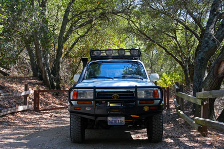
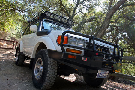
9/11 is a day that will live in infamy, of course. But for me, there’s a silver lining now because 9/11/11 was the day that I purchased Toyotie. We recently passed the one-year anniversary of ownership. As a birthday present, I decided to detail Toyotie for the first time.
When done properly, hand-detailing is time-consuming and involves a lot of elbow grease. That is to say it’s pretty much a pain in the rear! There are several steps for the outside paint alone.
First, the vehicle is given a regular wash, preferably a power wash. If needed, Dawn or other specific soap is used to remove the old wax and such. Once everything is scrubbed and dried, it’s time to give every exterior paint surface a clay bar treatment. This is where you become truly aware of just how much surface area there is on an 80-series Land Cruiser!
It’s quite time-consuming and this is why detailing shops will charge $60, $80, $120, or more – on top of their regular fees – if you bring them a big truck or SUV. I went through an entire bottle of Meguiar’s Qwik Detailer and destroyed a clay bar in this process, but it was needed. The clay bar removes all the bit and pieces of “stuff” that’s still stuck to the vehicle even after a pressure wash & scrubbing. You can feel – and see – this detritus being removed during the clay bar process.
After the clay bar, it’s time to consider whether or not the polishing step is needed. In this case, it was, so now I have to go over most every inch of the exterior for the third and fourth time. At least I was able to skip the front bumper for this step… Polishing involves the most elbow grease of any step, especially if you’re working by hand as I was. Again, I became very aware of how much Toyotie there is! After the polish & buffing phases I’ve now gone over everything five times. My arms and shoulders are sore, but I’m not done yet.
I finish with two final steps: a thorough application of wax, and buffing. More elbow grease, but not quite as much as the polishing phase. The seventh and final pass buffs off the wax and leave the outside looking as good as it’s ever going to look, and protected by the wax layer.
Of course I wasn’t really done there… There were still all of the windows to clean – inside and out. The interior surfaces also needed cleaning and dusting, as well as vacuuming. The wheels needed cleaning. And so on. It was a lot of work but it was done right, and I spread the effort out over several days. Toyotie is clean and shiny for a change. For now.
I pretty much exclusively use Meguiar’s and Griot’s Garage car care products. That’s an unpaid endorsement, unfortunately.
Looking Back Over the First Year
When I bought Toyotie the odometer was at a hair over 198k miles, and it is currently closing in on 217k. That’s just about 19k miles if you’re bad at math. Or 30k kilometers if you’re foreign.
Toyotie came with several good (and expensive) upgrades and I added more. A year later, I’m particularly fond of the auxiliary fuel tank (although it was expensive and has not been entirely trouble-free) and the Engel fridge. I was also happy to have finally figured out how the iPod/iPhone works with the Alpine head unit and adapter..
There have been some important bits that have needed replacing as well: front and rear brake pads, the starter, brake booster, radiator, and several hoses. Also the power steering and valve cover gaskets. That’s quite a few things, but not completely unexpected with a 16-year old vehicle, and some (like the hoses) were strictly preventive maintenance. With any luck, most of these replacements should last another 16 years.
In true Toyota style, none of the parts failures left me stranded, although the radiator certainly could have, had it happened out on the trails somewhere. Then I would have needed to try out my radiator repair kit and hoped that it got me home.
As noted earlier, the auxiliary fuel tank has had some issues that have needed working through. The exposed fuel pump was damaged & leaked in Death Valley. The exposed fuel filter was damaged and leaked (much slower, at least!) in the Mojave Desert. Both were fixed and led to the addition of a small custom skid plate to guard those items. That seems to have cured those vulnerabilities, but now the rear axle breather tube has been cut where it passes though that skid plate… Sigh. That will be corrected soon, and hopefully that’s the end of those issues.
On the plus side, Toyotie has been fun, capable, and has seen us though a year’s worth of adventures, including well over 400 miles of offroading on a dozen occasions. There’s plenty of room inside for people and “stuff”, and it’s comfortable too.
I’m hoping that the next year will bring even more offroad miles, and fewer repairs, if those things aren’t mutually exclusive. To quote my legendary Jeep mechanic Jeff Arabia, “I love how you offroad the fu__ out of that thing and beat the sh__ out of it!”
I’ve created a small image gallery with some recent updates and photos.
Happy birthday, Toyotie!
The Lost Coast, Part Three
When I left off in Part One and Part Two, we’d just completed Usal Road and arrived back at pavement at Four Corners. From there we drove north on Chemise Mountain Road, which was much like a (mostly) paved version of Usal Road. Before long we reached Shelter Cove Road and began the big downhill drive to Shelter Cove.
On the way we stopped at the Shelter Cover General Store for some supplies. They have a gas pump there but it was very expensive if I remember correctly. Fortunately, we were fine on fuel so that wasn’t an issue. There’s a Porta-Potty here too but you’re better off using the public restroom in Shelter Cover near the lighthouse and deli.
We drove into Shelter Cove and thought about eating at the Tea House but that wasn’t really our thing and we weren’t looking to spend a ton of money on lunch. Also, the place was deserted even on a Saturday afternoon. I have read that they’re retiring and closing in another week, which is unfortunate, because options are always good.
We ate instead at the nearby RV campground deli, and ate out on the patio with a dozen other people who mostly appeared to be locals. They smoked, fed the seagulls, and a guy with NRA stickers on his UTV drove it up and past each trash can where he fished out bottles for recycling. The town had a really weird vibe for us, but perhaps that’s to be expected in this very remote part of the state. Lunch was just what the doctor ordered!
After lunch we drove back up the hill out of town and turned north onto Kings Peak Road, our next stretch of dirt road which ran about 17 miles. It started off very well-graded and wider than Usal Road, so we made better time. We passed a few other vehicles and a couple of recreation area trailheads. We saw a ranger truck parked at one of those. The road gradually tightening up and became rougher, and there was no other traffic seen on those sections. At one point we reached a bridge and from there climbed up up up, and along a series of hairpin switchbacks.
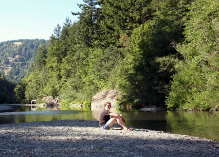
Eventually we again reached pavement at Wilder Ridge Road which we took to Mattole Road at the town of Honeydew, and from there it took a half hour to drive the 8.3 miles to our destination for the day, the A.W. Way (Humboldt) County Park next to the Mattole River. I had read that this park rarely seemed busy, but it certainly seemed crowded & busy to us! We lucked into campsite #9 which was right by the river and in a semi-secluded corner compared to most of the other sites. The site was very nice and the river was fantastic, and we splashed around its waters to get relief from the hot afternoon weather.
The crowds at the park left something to be desired, with people shouting and making nose well past (and before) the designated “quiet time”. Also the #1 rule for the park was that all pets must be on leash as a “common courtesy”, but few were, because their owners suck. 🙂 We expect this sort of thing at drive-up campgrounds though, based on previous experiences, so we can’t complain too much. On the plus side, there were good restrooms (until toilets in both men & women’s rooms were clogged and overflowed by other campers) and fresh water spigots at pretty much every site. This was quite the luxury compared to Usal Beach campground.
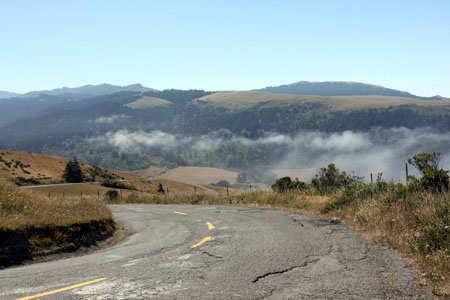
The next day after breakfast we departed and headed north on Mattole Road, up through the Cape Mendocino area, which is the westernmost point in California. The guidebooks speak of the horrors of Mattole Road: it’s narrow, twisty, and covered with suspension-shattering potholes… But of course all of these were nothing compared to Usal or Kings Peak Roads. In fact it was rarely narrow, I think there were no real blind corners, and the Land Cruiser went over the potholes like they weren’t there. We enjoyed the drive along the coast and the views from the coastal hills, and the weather was nice despite the coastal fog.
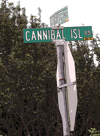
Completing Mattole Road, we continued north, briefly marveling at being on a highway again for a little over a mile. We hadn’t traveled in this sort of luxury for a few days now! We got off to explore the irresistibly-named Cannibal Island Road, and then continued on to the northernmost point of our trip, the Lost Coast Brewery in Eureka. After lunch and sampling the tasty beers we finally stopped for our only gas stop of the 683-mile trip, and drove back to Ferndale for the night.
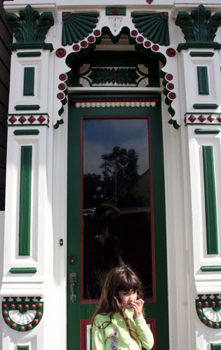
Ferndale is a very pretty town. In fact it’s the 11th-prettiest in the country, if Forbes is to be believed. We were inclined to agree, with the many charming Victorian-style buildings and more. There are lots of snapshots of them in the gallery. We explored the downtown for an hour or more, and bought a few things at The Blacksmith Shop and Golden Gait Mercantile, before settling in at the charming old Ivanhoe Hotel for the night. After chillaxin’ on the porch with a beer, we had a good dinner across the corner at The VI Restaurant in the Victorian Inn. We stuffed ourselves and waddled back to our room for the night.
After breakfast at Poppa Joe’s a few doors down the street, we started the journey home. It didn’t take long to reach the northern end of the Avenue of the Giants Highway, which we drove the length of on our way south. We stopped at a touristy gift shop, the Humboldt Redwoods State Park visitors center, and at a random spot among the amazing redwoods to enjoy the place.
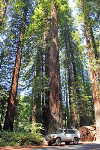
From there it was a long slog south back to San Jose, with just a pit stop at my usual convenience store in Novato for snacks, drinks, and a quick bio break. We arrived home a little before 6pm, tired but happy. It had been another excellent road trip, and it was time to start scheming plans for the next one…
The Lost Coast, Part Two: Usal Road & Beach
Since my friends Anthony & Astrid (@Overlandnomads) were heading up to the Lost Coast area just a week after our trip, followed a few weeks later by friends Lou & Nancy (@OnlyDirtRoads), I quickly threw together what information I had that might be of value in their trip planning. I’m now reproducing that information here, along with additional links and info. Note that I’ve already covered some of this information and posted a lot of related photos in Part One of this series.
Disclaimer – This information is provided from the best of my recollections, as well as my photos and GPS data, and is written from my personal (and subjective) perspective. Use of any of this information is at your own risk and responsibility – period. Don’t let anything written here override your own personal common sense or safety.
I’m going to try to cover pretty much everything I know from my research and our recent visit to Usal Beach, Usal Road, Usal Creek, and Usal campground, with a side of Usal fries.
We drove Usal Road from its southern terminus with Highway 1, to it’s northern end at the Four Corners intersection. You could of course drive it the other direction, but everything here will be written in order from the perspective of south-to-north.
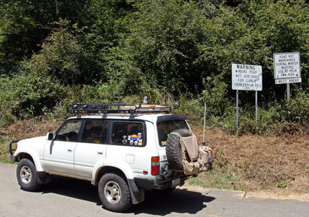
So let’s start with the southern end. You pull off Highway 1 at about N39º 46.823′ W123º 49.894′, where you are greeted with a variety of signs. Several yards past that there is a gate, which was open when we were there. I’ve read that this gate can be closed for seasonal (mud!) reasons or because of overcrowding, but this latter scenario would seem unlikely. From here it’s around 9.4 miles to the Usal Beach campground area. I drove it in about 20 minutes but your time may vary, especially if you’re the middle-aged woman driving the silver CRV that was in front of us for a while…
This section of Usal Road was a well-graded, narrow but easy dirt road. This was during the dry season. During the rainy season, it may be difficult, impassible, or outright closed. The road is narrow, with some pretty blind corners, so stick to the right, go slowly and be very alert for oncoming traffic. And if someone catches up behind you, do the goddam courteous thing and let them pass when you can safely move over for them.
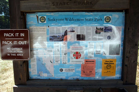
You know you have reached the campground area when you encounter the park sign which is posted with numerous warnings and regulations. This is a fee area and the fees for camping, day use, etc. are posted. Overnight camping was $25 at the time of our visit. Unfortunately, the “iron ranger” pay station has been decapitated, so no one was leaving money for the park fees in it. I would pick up & fill out an envelope, then pay a ranger if one happens to show up. If you leave money, someone’s gonna just grab it.
As a California state park that has mostly been abandoned, there are no trash cans and no trash pickup. Pack it all out. Also, bring your own TP or you’ll be taking your chances. There are several outhouses scattered around the camp area, so you can pick the least hellish one.  Bring your own drinking/washing water.
There are fire rings at the sites. Our site conveniently had wood & kindling already, otherwise bring your own if you want a campfire. Each site also has a picnic bench.
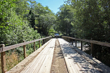
Our site was a good one. After passing the camp area entrance board, you soon cross the cool wooden bridge over Usal Creek. There’s a road immediately after it on the left, where there’s also a memorial plaque. Pass it, and keep straight for about 80 yards and there’s another road on the left, and this one is very easy to miss. Take that left and our site was the first one on the left, after maybe another 50 yards. The coordinates are N39º 50.111′ W123º 50.638′. We liked this site, although you could probably find one that was a little more secluded, or closer to the beach if you wished.
We were apparently naughty as we briefly drove around on Usal Beach, which was some 600 yards from our campsite. I’ve since heard that this is not permitted and that the rangers will ticket you if they see you doing it. We didn’t see any signs, had read of others driving on the beach, and saw other tracks on the beach, so had assumed it was OK. Now we know better.
Speaking of infracting the regulations, the locals apparently like to party out here. When we were there, they were drinking, driving around fast, yelling and playing music until around midnight. Oh, and apparently setting off artillery shells on the beach, if the enormous explosions we heard were any indication. One family’s kids threw rocks at the elk, and the big group of young people left their campfire unattended. One description I read of this park said that the locals turned it into a “wild west” on weekends and now I fully understand that description. Fortunately we also met well-behaved and friendly visitors as well.
During weekdays, I expect this campground to be less busy and quieter. If you’re going up for a weekend, I suggest trying to arrive as early as you can (preferably Friday afternoon or earlier) in order to have the best pick of campsites. There are no reservations taken.
Heading north from the campground area, it’s about another 19-1/2 miles until you reach pavement again at Four Corners, and the end of Usal Road. When we drove it, the road was still freshly graded for a few miles from the campgrounds. Beyond that, I got the impression that they hadn’t graded the road this season. It was definitely a little rougher and more rutted, but still nothing that I would call technical, at least not that I can recall. In those conditions, personally I wouldn’t think twice about driving it in a stock 2WD pickup, for example. But I can’t speak for every driver or their vehicle.
Related Info
We had zero AT&T cell/data reception the entire time we were in this area, and well beyond. That includes Shelter Cove and most of Kings Peak Road to the north. We didn’t have reliable coverage we could count on until we reached Ferndale to the north. We did see people using cell phones in Shelter Cove, so perhaps Verizon works there.
The cheapest gas we saw on the trip was in Laytonville, on Hwy 101 south of where we turned off towards Usal Rd on Hwy 1. It was as low as $4.02 there. Most places along our four-day the trip were closer to $4.29/gallon, including Eureka, although I think the gas at the Shelter Cove convenience store was substantially higher. Of course, by the time you read this, the prices have probably swung one way or the other, but they likely stay fairly relative to each other.
Reference
In California Coastal Byways (Tony Huegel), Usal Road is Tour 14, and King’s Peak Road is Tour 11.
Both roads are listed under trail section 4 in the Guide to Northern California Backroads & 4-Wheel Drive Trails (Wells).
They are missing from the Backcountry Adventures – Northern California (Massey & Wilson) book for some reason.
Wilderness Press offers a nice, waterproof Lost Coast recreation map. The information for Usal Road is incomplete though, so it’s a useful map but I wouldn’t rely on it to have everything you might want.
California State Parks Sinkyone Wilderness SP official website.
Map
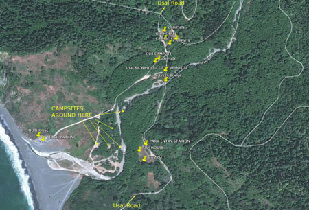
I hacked this together with Google Earth, showing an overview of the Usal Beach area. I’ve added rough waypoints for the campgrounds, outhouses, and such that I remember. I didn’t go around marking or noting them all though, so there are surely others scattered around the area. The top of the map represents map north.
On the map, the thing labeled to the farthest right is where Google has helpfully labeled Usal Creek as “Usal Road”. Ignore that.
If you have any questions, please feel free to add them to the comments below. I’ll help if I can.
Part Three of our Lost Coast trip will be up next to wrap things up.
The Lost Coast, Part One
The Lost Coast
The Lost Coast really came to my attention when we went on our first group offroading trips back in 2002. I’d heard the term before, and knew from a previous road trip up the California and Oregon coasts that it was an area where the highways went inland, strangely bypassing the far-western cape of California. Like everyone else, we’d followed the major highways north and inland, bypassing it too. That was all I knew about it at the time.
In addition to the Henness Pass and Cisco Butte trips we took in ’02, the CA4WDC group at the time also offered an SUV trip in this enticingly-named area. I read the brief description in the club newsletter. We liked the northern California coast and redwoods, so we knew right away that we wanted to do this trip too.
We could have gone the following year, but we had a newborn baby to deal with. An offroading trip with camping was not really in the cards! Unfortunately, at some point soon after, they stopped offering this annual trip. I don’t know why.
I still thought about it now and again over the years, and it was on my lengthy “You know, I really want to check out this area….” list. Somehow, it stayed on that list for a full decade. Until now. It was time to finally check this one off the list. So I did my research (books and the internet) and planned it as a four-day trip, Friday through Monday.
The Plan
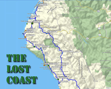
FRIDAY Drive from San Jose to the southern end of Usal Road off highway 1, then on to Usal Beach and the campground there in the Sinkyone Wilderness.
SATURDAY Drive the rest of Usal Rd. north to Four Corners, then on to Shelter Cove for lunch. Continue north on King’s Peak road (17mi more dirt = fun), then on to the AW Way park campground next to the Mattole River.
SUNDAY Continue north on Mattole Road to Cape Mendocino, Ferndale, Cannibal Island Road, then up to Eureka and the Lost Coast Brewery for lunch. Return to Ferndale and stay at the old Ivanhoe Hotel.
MONDAY The long drive home. Drive the entire Avenue of the Giants Highway along the way, stopping for the sights here and there.
My main goal was to drive Usal Road, a coastal dirt road with a big reputation among backpackers and others who ventured into the area. Whenever people wrote about Usal Road, it always had some sort of epic feel to it. Usal Road was an itch that needed a long-overdue scratching.
Let’s Get Going Already!
Plans made, maps studied, waypoints marked, and Land Cruiser packed, we departed San Jose on Friday morning at 0800. Our northward direction of travel helped us to avoid most of the Bay Area morning commute traffic, and I was able to drive an entire hour before being asked to make a restroom stop! We made good time up highway 101, then cut west on Highway 1 to the southern end of Usal Road, where the real fun would start.
During the dry summer season, Usal Road is an easy, well-graded dirt coastal road. It’s pretty narrow for the most part, but we encountered only one oncoming vehicle on the drive out to Usal Beach. You could drive this part of the road in just about any car. In the Land Cruiser, I just had to watch for other vehicles and the occasional pothole or rock. The road climbs up along the coastal range and every so often offers up an enticing overlook of the pristine coastline.
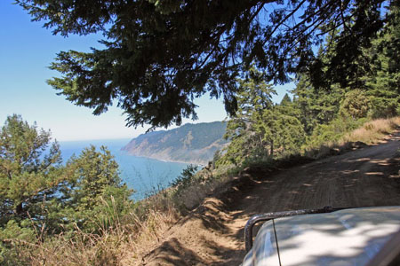
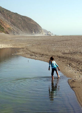
Starting Usal Road at 1:15pm, we made good time over the next 9-1/2 miles and had arrived at the campground and selected a promising-looking site by 1:40. We put up the tent, tossed in the sleeping gear, and then drove to the beach which was about 600 yards from our site. We enjoyed a quick (but possibly illegal) drive on the beach before parking back on solid ground, and then spent the next hour enjoying the beach on foot. We also spotted our first elk who were hanging out among the grass by the beach.
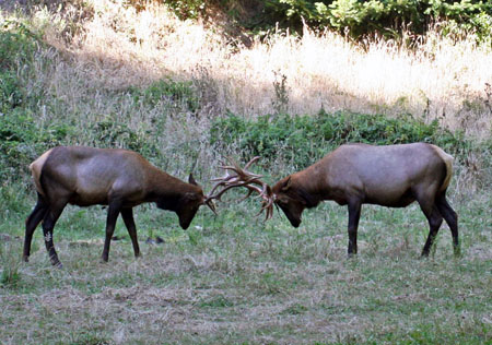
Returning to camp we finished setting up, and more elk grazed just on the other side of the dirt road from us. Before long, two of the bulls started sparring a mere thirty yards from us, as we watched in a state of wonder. The CLACK! of their antlers coming together was almost the only sound of battle, until the older bull got the better of the young challenger, who then made piteous sounds of “Eeeeeeaaaah!” when his head and antlers were getting twisted enough to cause him some obvious pain. We certainly hadn’t expected to be treated to this show of nature, but we’ll remember it for the rest of our lives.
Avoiding the elk, Allison picked ripe blackberries by the dozens from the many nearby bushes, and we ate dinner (spaghetti and sourdough rolls) and dessert (raspberry crumble, and the fresh blackberries) before going to bed early. The local party crowd made noise until around midnight, but we made up for it by sleeping in late the next morning. The weather was perfect too, never uncomfortably hot or cold. After breakfast (crepes, coffee, and bacon!) we packed up and got ready to go.
The elk were back and our campsite neighbors who had arrived after dark were as in awe of them as we had been the previous day. I chatted with Frank, the French-accented father of the family, who told me they were going to be backpacking in the wilderness for the next day. It sounded good to me! Then as were departing, a couple of young local boys had appeared and decided to throw rocks at the elk, so we took them back to their parent’s camp and ratted them out. I hope they got a good talking-to, but who knows. Meanwhile, I also noticed that the hard-partying young locals had left their campsite fire unattended, to the dismay of myself and their camp neighbor, a heck of a nice guy who they’d kept awake half the night.
We finally left the campground, driving north the rest of the way on Usal Road, covering the remaining 19+ miles in an hour and 22 minutes. The road was still well-graded for several miles, but then it seemed like they’d not graded the rest of the road this season. It still wasn’t bad at all but there were definitely more ruts and bumps. It was a scenic drive through the forests, typically at 10-25mph. The air was fresh and clean and the day warmed up quickly as we drove.
Along the way, we encountered a solo bicyclist – a scruffy, bearded guy in a tie-dye shirt – and then a couple of enthusiastic dirt bikers at the very northern end of the road, but that was all the traffic we saw. We’d reached the Four Corners intersection where Usal Road ended and the pavement began. From there we’d continue on to Shelter Cover for lunch.
Coming Up Next
The trip report will continue in Part Three, but because there’s been a lot of interest in this area of the Lost Coast, Part Two is going to offer as much detail as I can manage to serve up on Usal Road, Usal Beach, and our experiences there. My goal is to provide trip-planning information to those who would like to visit the area. Look for this next post soon.
