Drive #9: Big Pine Flat Trail

Big Pine Flat Trail
Date Driven: 10/24-25/13
Length: 26.6 miles
My drive time: 3 hours
Start: intersection of Green Valley Lake Road and Crab Flats Road, N34º 14.013′ W117º 05.364′
End: At pavement at Holcomb Valley Road, N34º 18.214′ W116º 49.355′
GPS Track: GPX or KMZ format. (right click -> Save As)
Source(s): Trail “South Coast #13” in Backcountry Adventures: Southern California (Massey) was my primary source for this drive. Different segments of this trail are listed under several drives in Area 6 (Big Bear, Lake Arrowhead) in the Guide to Northern California Backroads & 4-Wheel Drive Trails (Wells). An excellent paper map, Off-Highway Vehicle (OHV) Guide, San Bernadino National Forest 2012 is also available.
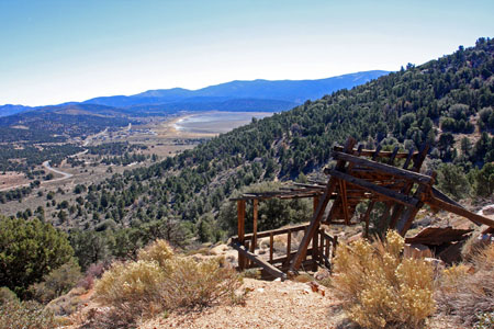
Summary: This drive is a very scenic and generally very easy trail that runs through the Holcomb Valley north of Big Bear Lake. I drove it from west to east. Elevation runs from roughly 5,500′ to 7,600′.
Description: Beginning at its western end, the trail starts off pretty smooth and winds among the hills down to the Crab Creek crossing which was a lot of fun for us. A few miles later the terrain opens up and includes boulder-topped hills and pine forests. It’s very pretty and if I lived closer I’d surely come here often. There are several marked scenic and historic sites as you near the eastern side, including wonderful sweeping views at the old Lucky Baldwin gold mine site.
Full details of my visit to this trail, and a large photo gallery, can be found in my blog post Mountain Rendezvous 2013 – Part Two.
I had AT&T cell coverage on the western and eastern ends of the drive where I was at higher, unobstructed terrain. I didn’t keep close track other than that.
I’ve cleaned up and combined my two original tracks for this drive as usual. Remember to use it as a general guide, not as a perfect and exact resource.
There are several camping options along the trail or nearby. There are full campsites, although only two were still open for the season when I was there – Holcomb Valley, and Serrano which is on the north shore of Big Bear Lake. There are also “yellow post” primitive sites, as well as dispersed camping options. For availability, fees (if any) and regulations, Adventure Passes (if needed) and general info, check with the SBNF Discovery Center at 40971 North Shore Drive, Highway 38, in Fawnskin. Be aware that (as of this writing) they are closed on Tuesdays and Wednesdays. Their phone number is (909) 382-2790.
Disclaimer – This information is provided from the best of my recollection and is necessarily subjective. GPS data is from a personal device inside my vehicle, so coordinates will not be exact. Use of any of this information is at your own risk and responsibility – period. Conditions change (especially in winter), vehicles and driver skills vary, etc. and I have no control over these things. Don’t let anything written here override your own personal common sense or safety.
Hello was this rd easy to find n when your on this trail is it easy to get to big bear lake? Is there signs directing me or just have to know the trail?
January 2nd, 2015 at 10:36 amHi Chrystian, the trail was pretty easy when I drove it and well-signed but I also had my route with all the intersections laid out before we drove it. It’s always good to have the proper map(s), particularly when you intersecting trails to choose from.
You’ll also want to check on the conditions since they have had good snow up there now. Trails may be closed or impassible. We didn’t have to worry about that when we were there. Good luck and stay safe.
January 2nd, 2015 at 6:21 pm[…] Photo Source: Backroad Navigator […]
June 9th, 2016 at 4:13 pm