Mountain Rendezvous 2013 – Part Two
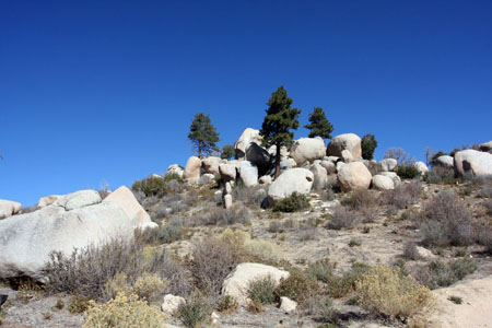
Friday morning, I grudgingly awoke and climbed out of my warm, cozy sleeping bag in the back of the Land Cruiser. The fall temperature had dropped into the upper 30s overnight and we were camped at about 6,500′ elevation. As always – but especially when it was cold like this – coffee was the absolute first order of business this morning after brushing my teeth. Everywhere around us were bright orange, yellow, and red autumn leaves. The small hillside next to me was topped with very Sierra-like granite boulders. Not bad for a random campsite.
After the coffee (Starbucks Via) I heated up my trusty and simple breakfast of Mountain House blueberry oatmeal, appreciating the warm food as I also heated my hands around the stove. My plan for the first camping spot here was to minimize the cooking effort and cleanup, so I was eating backpacking food out of the bags, and just heating up water via my pack stove. The rest of the weekend I’d set up and use my chuck box and proper camp kitchen. And the Dutch Oven.
After breakfast we again said goodbye to Bente and Hans and drove down to check on the water crossing where I’d turned around the previous evening. This time there was no one else there. Also the tree had been cleared and fresh tire tracks led into and out of the water crossing, all from the ranger pickup we’d seen drive through a short time earlier that morning. It was a beautiful spot and we scouted around, checking our options.
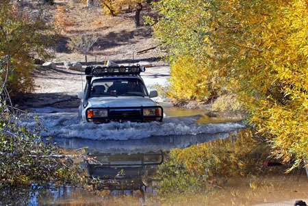
I decided to drive straight through. Gianni, however, had several inconvenient openings in his Jeep TJ which was still very much a work in progress. The missing transfer case breather was one of the more glaring issues. Rather than risk sucking in water, he opted to take the alternate route, skirting the water, going up the rocky surface on the other side before swinging 90-degrees left around a large boulder, then quickly negotiating a pit before reaching the easy trail again. In any case, we each made it through without any drama, and had a lot of fun in the process!
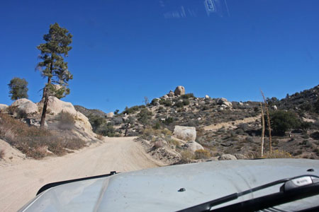
Beyond the water crossing the trail was pretty straightforward, aside from a few mildly technical rocky areas. Like many dirt roads, we mostly had to watch for the occasional dips and whoop-de-doos. As we progressed eastward, the terrain widened up and we enjoyed the pine forests and boulder-covered hilltops. We drove through one area that had been burned by an older fire where there were stark white trees. Passing through the Holcomb Valley we stopped to check out several sights I had marked with waypoints, including a mysterious grave, some alleged saloon remnants, the pygmy cabin, and a (also alleged) hanging tree.
The trail was pretty well signed throughout, which was helpful as confirmation of my route. It was good that – prior to the trip – I had laid out the route fully in my handheld GPS, as none of the topo or road maps in my iPad’s MotionX apps were entirely complete. Sometimes the forest road names also conflicted between my electronic maps and my Massey guide book, adding more potential for confusion, but as it was we navigated through without incident. It helped that when in doubt, we could simply follow the “main” trail, for the most part.
We really enjoyed this scenic dirt trail, which lasted over 26 miles. The weather had warmed up and was perfect for t-shirts, and the fresh mountain air was a real treat. Our elevation along the trail varied from roughly 5,500′ to 7,600′. We passed a few vehicles along the way but most of the time had the place to ourselves. I was hoping to see more wildlife, but other than a large deer zipping in front of me at one point, the critters were scarce… Probably because it was also hunting season!
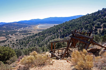
Near the end, the trail became rockier and tightened up, contouring along hillsides on shelf roads, but still generally wide enough for two vehicles to squeak past each other. We reached the old Lucky Baldwin gold mining site and were treated to wonderful panoramic views of Baldwin Lake, and the Johnson Valley to the northeast, in addition to the wooden remnants of a large ore bin at the mine. After taking photos and enjoying the views, it was less than a mile of downhill descent before we’d reached pavement again, next to a very large landfill site.
From there it was a short drive into Big Bear City where we topped-up our fuel tanks (I was now good to get home!) and picked up some food from a small market. Then we had a half-hour drive up and down Highway 38, which peaked at 8,436′ on my GPS, making it one of the highest highways in southern California. The fall colors continued to put on a real show for us, and that crisp mountain air was always a treat for me.
We arrived at Camp Tahquitz for Mountain Rendezvous 2013 at around 1:15 that afternoon, and that’s where I will pick up on the next post.
Mountain Rendezvous Part Two – Big Pine Flat Trail photo gallery