Drive #7: South Coast Ridge Road

South Coast Ridge Road
Dates Driven: 11/18/07 and 7/5-7/13
Length: NW end of SCRR to Highway 1 at the SW end of Los Burros Rd., 23.2 miles. almost all dirt.
My drive time: 1 hour, 50 minutes
Start: intersection of Nacimiento-Furgusson Rd and South Coast Ridge Road, N36º 00.587′ W121º 27.149′
End: Intersection of Los Burros Rd. and Highway 1, N35º 53.146′ W121º 27.518′
GPS Track: GPX or KMZ format. (right click -> Save As) Please note these have been edited to combine the tracks from both days. It also includes our side trip to/from Alder Creek campground, which adds 2.7 miles and 23 minutes to the drive info shown above.
Source(s): Tour 21 in California Coastal Byways (Tony Huegel), and trail #52 in the Guide to Northern California Backroads & 4-Wheel Drive Trails (Wells). Both cover pretty much the same route that I chose. The length of SCRR (only) is covered in Backcountry Adventures – Southern California (Massey) as trail CM49.
Summary: This drive covers 15 miles of the 25-mile long South Coast Ridge Road (SCRR) before turning onto Los Burros Rd. and driving to our Independence day weekend camp site. From there we visited the Alder Creek campsite down a rougher side trail, before heading back and down Los Burros Rd. to Highway 1.
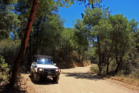
Description: Beginning at its northwest end, SCRR is a well-graded dirt road. Its often wide enough for vehicles to easily pass each other, but in some places it narrows to a single vehicle width. We made excellent time, while keeping our speeds moderate in case of oncoming traffic on blind crests and corners. As it turned out, we encountered no other traffic on this, our second visit. SCRR got a bit rougher in places as we neared the southern portion of our drive on it. Los Burros Road and the spur road to our camp were also recently graded. The side trail to Alder Creek camp was rougher and included large ruts to navigate.
There are numerous intersections and side trails, so good maps are recommended. There are no services or facilities along this drive, and our cell service was very sparse.
For a description of our overnight camping trip here and related information, check out this post.
Disclaimer – This information is provided from the best of my recollection and is necessarily subjective. GPS data is from a personal device inside my vehicle, so coordinates will not be exact. Use of any of this information is at your own risk and responsibility – period. Conditions change (especially in winter), vehicles and driver skills vary, etc. and I have no control over these things. Don’t let anything written here override your own personal common sense or safety.
Actually getting around to doing this is so insanely organised that if I didn’t like you I’d not like you. 😉
July 15th, 2013 at 4:29 pmHahaha! It helps a lot that I have a template and I can more or less just fill in the variables and a quick description… And I don’t do too many of them. I do have another one I’ll post soon though, so hopefully they are useful to someone, somewhere.
July 15th, 2013 at 6:48 pm