South Coast Ridge Road – N35º 52.688′ W121º 24.133′
We first explored a portion of South Coast Ridge Road (SCRR) back in November of 2007. Then perhaps two years ago I found myself discussing the area with a couple of “overlanding” buddies. One of them had recently camped there and was enthusiastic about the spot where they had camped, overlooking the Pacific. I duly noted down the coordinates, did a little preliminary research, and filed the info away in my mental “to do” list.
Fast forward to the present, with the long Independence Day weekend fast approaching. Budget and various other of life’s necessities had curtailed a number of road trips I’d recently hoped to do, but happily everything came together for this overnighter since it wasn’t far from home.
We enjoyed the annual July 4th neighborhood fireworks displays at home, got everything packed and ready on Friday, then got our trip underway around 0900 on Saturday morning, making the 130-mile drive south past Big Sur on Highway 1. Arriving at Nacimiento-Fergusson Road, we made our way east to the top of the first coastal ridge where South Coast Ridge Road – and the dirt and the fun – began.
SCRR is about 25 miles long, ending at a locked gate on the border of Fort Hunter Liggett. We’d be taking the road roughly 15 miles before veering off onto Los Burros Road and some associated trails. We hoped to be able to claim our desired campsite, spend the afternoon and night there, and check out another nearby campground before descending again to Highway 1 and heading home.
The scenic drive south on SCCR was uneventful and we encountered no other vehicles along the way. Here we were above the coastal fog and it was much warmer than I – or the weather wonks – had anticipated. We enjoyed the expansive views in every direction as we cruised south at moderate speeds along the spine of the coastal ridge.
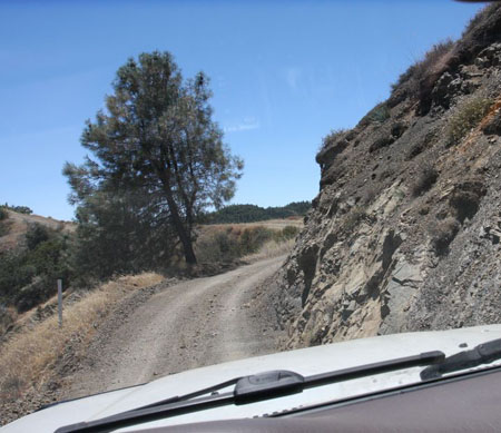
I kept a close eye on my iPad navigation screen – with occasional checks of the handheld GPS – as we eventually met up with the intersection where we’d say farewell to SCRR and make our way on Los Burros Road to our camp.
Our campsite seems to be an unofficial one. In the area there are several similar sites, and I know they get a lot of use. Officially, the USFS district here doesn’t permit what is called dispersed camping, which is camping outside of designated campgrounds. In practical terms, they do seem to tolerate it at these and other nearby locations, but don’t blame me if a ranger tickets or evicts you.
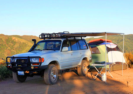
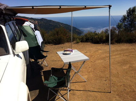
We were happy to pull in around 1330 and discover it empty. The site was at a wonderful sort of dead-end cul-de-sac on top of a hillside knoll, at just under 3200′ elevation. It offered spectacular views in every direction, seclusion, and a wide flat area for camping, but no shade or shelter. We parked and set up the awning, table and chairs and settled in for a welcome lunch break. On the downside, flies and gnats quickly decide to swarm around us, which was annoying but it was better than being devoured by mosquitoes.
After lunch we set up the tent to escape the buzzing irritants, and we spent a couple of hours sequestered inside where it was rather toasty. Eventually, I took the unusual measure of offering up a little air-conditioned escape inside Toyotie for the sweaty and tired family, who immediately and gratefully accepted.
After 15 minutes or so everyone was comfortable again, and soon after that the sun had descended enough to cool things off nicely. Happily, the bugs had thinned out too and were now quite tolerable. To our delight, the mild weather and lack of bug swarms remained in our favor for the duration of our stay. Woohoo!
Like the closest official campground, our site lacked any water or restroom amenities. We came prepared, however, and had plenty of water and cool drinks available. I also set up the PETT toilet and tent so that we’d do our part to Leave No Trace. We of course packed out all trash and waste.
As the sun set we enjoyed the spectacular views, dinner, and some photography. Allison spent some time running around and exploring like a proper kid. Even after the sun had set out at sea over the low fog, the orange and purple glow it left behind lasted well over an hour. When it was finally dark, the stars and the wide swath of the Milky Way’s glow provided our evening entertainment and relaxation.
Sometime around perhaps 2230hrs we heard a vehicle on the approaching dirt road. The sound of the speeding engine was accompanied by the occasional sound of spitting rocks and dirt, and even a couple of inadvertent horn honks as the wannabe-rally driver sped through the darkness. As they approached our site, we stepped well back to the sides and I took a forward position, signaling our presence with my headlamp as their headlights appeared.
Happily, the driver immediately slowed as he approached. The young man behind the wheel (of a car that had seen better days, and no wonder) greeted us, made a brief apology for having intruded, and carefully turned around before departing as quickly as he’d come.
We returned to our relaxation and peace and quiet, stargazing for some time before turning in for the night. Another vehicle approached our camp at around 0030, but spotted us and turned around before heading off to seek out an unoccupied site. I got up for a bio break and saw their lights as they settled into what had been our “Plan B” site just a short drive down the trail from us. As it later turned out, another overlanding acquaintance of mine had just spent the previous night at that very spot. Small world!
I was awoken early (too early!) the following morning by warm sunlight coming over Alder Peak to our east. We slowly stirred and enjoyed the view of the morning fog along the coast below us. We got up and had a blissfully good breakfast of hot coffee, bacon, and scrambled eggs. We lounged around a bit, enjoying the cool and quiet morning before we decided to break camp and move on.
Our next order of business was to check out the nearby Alder Creek campsite. The side trail to that camp obviously hadn’t been graded this season, and I had to carefully choose my line among the rocky, heavily rutted trail. We arrived at the wooded camp and found one of the two sites occupied by a lone Jeep Wrangler. Each site had a picnic table and a steel fire ring/grill, but the latter couldn’t be used due to current fire conditions. Only camp stoves were permitted, and then only with the appropriate USFS stove permit. I didn’t see any other amenities like water or toilets.
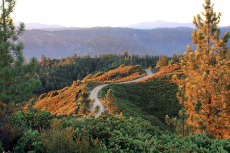
Curiosity satisfied, I switched into 4-Low and backtracked uphill the way we’d come. Once we arrived back to the graded trails of the main intersection, we began our descent down Los Burros Road towards Highway 1 and the coast. At 1800′ we encountered the cool coastal fog we’d been staring down upon from our campsite, and it felt good. Before long we reached the paved highway (boo!) and I turned north towards home.
We stopped as planned for lunch on the back deck of the Big Sur River Inn. After eating we completed the long drive home to San Jose, which took an extra half hour thanks to the holiday traffic. But we’ve had much worse and it was a small price to pay for a fun weekend.
Details of our route can be found in this associated Drive post.
South Coast Ridge Road photo gallery
WOW! Looks amazing, and sounds like a fun quick get-away. 🙂
July 14th, 2013 at 8:05 pm