40,000 Miles with a Garmin 60Cx

We interrupt my Hawaiian vacation ramblings to bring you, well, different ramblings.
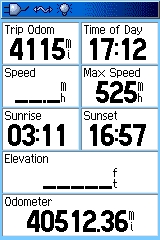
The overall odometer on my trusty Garmin GPSMAP 60Cx, which I’ve kept going since I bought the GPS three years ago this month, passed the 40,000 mile milestone while we were in Hawaii.
Since I subtract air miles, the 40,427 miles represent walking, hiking, mountain biking, and driving. I don’t have the GPS on while driving unless I need it. That might involve geocaching someplace, driving to a park, driving to remote work locations and back when I was working out of various REI stores around the San Francisco Bay Area, driving on vacations or day trips, and so on. The miles would be much higher if it the GPS was turned on during every routine commute drive, trip to the store, etc. Still, 40k represents a lot of time spent with that 60Cx.
Additionally, before the 60Cx came out in 2006, there were two years of using its predecessor, a 60C, to the tune of some 28,471 miles. Since the two units are mostly identical in function (and the same in external appearance), we’re really talking about a combined 5 years and close to 70,000 miles with this series of GPS. That’s a lot!
When it was released, the Garmin 60 series quickly became the gold standard for handheld/outdoors GPS. The 60 was available in several forms, but was first most popular in the 60CS version. My 60C omitted the troublesome electronic compass and separate barometric altimeter. Lacking those features, the 60C less expensive and had a substantially longer battery life than the 60CS. Two years later when the “X” models were released, I again opted for the 60Cx over the most popular model, the 60CSx, for the same reasons.

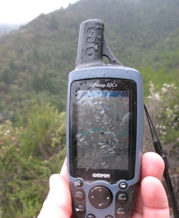
60Cx on a recent rain hike, one of many it has endured.
The 60Cx has been a versatile and reliable GPS. Over the years, I’ve passed on the opportunity to switch to several other GPS handhelds, from different manufacturers, often because of reliability issues. Besides routing me to the nearest Starbucks, gas station or geocache (which are important enough as it is!) I rely on my GPS in more serious circumstances.
My 60Cx has been used when backpacking, exploring unfamiliar areas, and in competitive offroad desert rallies. I carried it as a professional instructor in land navigation, geocaching, and of course GPS. It’s been used for a variety of purposes in my role as a Search & Rescue volunteer. That work includes searching not just for missing people, but also for bodies and important evidence, like bags of meth and submachine guns. Serious stuff.
Over the years the only trouble I’ve had with my 60Cx have been pretty minor issues overall. In the last year or so, it has sometimes lost the ability to access the maps on the microSD card. It might be strictly a connection issue, but the problem has also only happened when I’ve been using third-party maps, so the issue may very well lie with those. Power-cycling the unit is sometimes needed to regain access to these maps. It’s probably happened a half dozen times. When it has happened it’s only been a very minor inconvenience, but I do consider it a problem, and an annoyance.
The GPS has also crashed a few times while in the turn-by-turn navigation mode, usually when recalculating a route. That’s probably happened three or four times in the time I’ve had it. Those times were also annoying, but luckily never caused a serous problem. Thinking back, I don’t think it’s happened for almost a year now. Maybe one of the firmware updates took care of it?
It should be noted that I’ve seen more serious problems from most every other handheld GPS that I’ve spent any time at all with, and within much, much shorter periods of use. Neither of my 60s have ever needed service, despite some occasional abuse and eventually wearing through some of the button labels.
Overall I’m very happy with the 60Cx. It has performed as both handheld/outdoor GPS and as my vehicle GPS. I’m not sure there’s a truly more versatile unit out there. The DeLorme PN-40 and the Garmin Colorado and Oregon models offer some very attractive features, but also come with their own drawbacks. I’ve still not seen any GPS convincingly take the 60CX/CSx’s place as the model that all others must be compared against. Maybe Garmin will come up with another home run, or perhaps DeLorme will continue their steady progress and blow the competition out of the water with a spectacular, utterly reliable PN-60 someday, but we’re not there yet.
At some point I’d like to continue with some tips, experiences and more thoughts about the Garmin 60 series. But for now I want to wind down this post up with some screen shots.
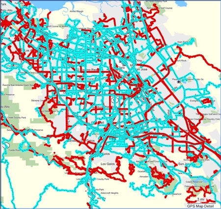
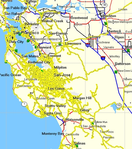
I keep most of my GPS tracks, although I seem to have lost many. All of the ones prior to 2005 appear to be gone. The misplaced tracks include some long trips, and some big hikes. Still, I gathered up what I still had available and set about forcing them down the gullet of my software and CPU en masse, and below are some of the results. (Click on any of the first three images to see larger versions.)
4½ years of geocaches & other waypoints around San Jose
Local tracks over the same period.
Same tracks shown over wider area.

Tracks starting and ending at my house.
I’ll conclude with some a little statistical trivia. These numbers are certainly not intended to be boasting or competitive! Many, many people have had the good fortune to travel more than I have. Rather, these are just some of the tidbits as they have been captured by my 60Cx over the years, and they’re more for my reference than anything else. They obviously don’t include coordinates for places I’ve been without a GPS, or some would be very different.
In some case, I have noted additional, approximated coordinates to represent locations where I should have a track, but don’t for some reason.
STATS
- Odometer miles: >40,000
- Fastest speed recorded, air: 525mph
- Fastest speed recorded, land: 124mph
- Lowest elevation: about -11′
- Highest elevation, air: 35,968′
- Highest elevation, land: 13,900′
- Northernmost point: N46° 11.705′ W123° 46.496′
- Southernmost point: N18° 54.679′ W155° 40.915′
- Easternmost point: N39° 30.813′ W118° 56.432′
- Westernmost point: N19° 44.243′ W156° 02.481′
I wish the 60 series recorded how many hours the unit had been on during its life as some electronic devices do, but unfortunately they don’t.
I’ve requested some new large-scale track parsing features in Dave Knapp’s AnalyzeTrack application, or perhaps an entirely new application to handle this sort of data. He sounded interested, but we’ll see… If I am able to put together some more interesting track data in the future, I’ll append it here.


I am SO impressed you have all these statistics! No way am I organised enough ever to do that!!
May 6th, 2009 at 3:22 pmIt wasn’t a real feat of organization or anything. I was just curious and looked up the info from my old track uploads. My weird brain likes this sort of thing.
I think that saving tracks is a good idea in general. They take up very little room and they can be very useful on occasion, for more than just trivia. 🙂
May 6th, 2009 at 4:29 pmHave you considered sharing some of this great data on a GPS-tracking community site like myGeoDiary (www.myGeoDiary.com)? With the search capabilities, it would be neat to compare your tracks with others.
May 7th, 2009 at 10:50 amHi Karen, and thanks for the suggestion. I’ve been meaning to get on there but as with so many things there is the challenge of having enough time.
For a number of reasons, it would not be appropriate for me to openly share all of my tracks. Because of that, I’d have to examine each track before deciding whether or not to share it, and that would be somewhat time-consuming.
Also, I think the tracks would be best with some supporting context and information, as well as perhaps some editing. That would require still more time.
But I’m hoping to look through some of my data and perhaps start sharing specific some of it, based on themes: specific parks, offroad trails, etc.
Thanks again for the pointer. That might expedite things considerably.
May 7th, 2009 at 11:14 am