N38° 48.658' W122° 22.626'
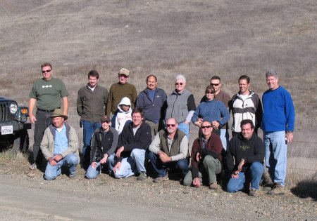
In mid-December, we had a group of 17 geocachers in ten vehicles link up at the BLM’s Knoxville offroad area for a day of geocaching and offroading.
Knoxville is located north of Lake Berryessa, about a half hour drive on the backroads from Napa.
Bill was the first person I linked up with since he met me at my house before the sun was up. It was chilly, but we were both happy that it was noticeably warmer than it had been on the previous few mornings. We were on the highway by 0645, and to our next scheduled rendezvous in Milpitas ahead of the scheduled 0715. We were then up to four vehicles, and we picked up two more passengers on a stop along 680 in San Ramon. Our last stop before Knoxville was for gas and the restrooms in Napa, and we arrived at the southern entrance to Knoxville at 1026.
At the entrance, we met up with Peri and Kyle in Peri’s TRD Taco. We waited about 15 minutes for the rest of the group to join up with us before heading in. They had come up the day before and had some exciting adventures offroading and caching up near Clear Lake, before heading down to meet up with us this morning. After the obligatory group photo and airing down, we finally headed into Knoxville just before 1100.
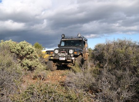
Almost as soon as we’d started, we’d reached our first geocache. We’d barely gotten off of the main tarmac and into Knoxville, when 3/10ths of a mile – and less than two minutes later! – we made our first stop. It was an omen of what was to come.
Since I’d first researched this trip several months ago, Knoxville had been pretty well loaded up with geocaches. In fact we’d be visiting two dozen of them while we were here. Depending on your personal disposition, this was either a wonderful opportunity to find a lot of caches, or it was a groove-buster that would see us halting, trying to find space to park everyone, and clambering in and out of our vehicles over and over again.
We’d not left the first cache before a couple of people were shaking their heads and saying that we weren’t going to be able to visit all the caches in Knoxville unless we picked up the pace. Others were clearly keen to take their time and a few pictures along the way. Soon after that we had some vehicles taking off ahead of the rest of the group, something we’d not had to deal with in our previous trips.
This continued on and off throughout the day, although the group generally stayed together. Getting geocachers – people who are normally used to operating at their own pace – to work together can be rather like cat-herding at the best of times. With ten vehicles, there wasn’t much I could do to control it even if I had been so inclined. I just crossed my fingers and went with the flow, giving some direction here and there, and fortunately we didn’t lose anyone or have any breakdowns to contend with.
We kept up this drive-cache-drive-cache until we stopped for lunch at 1310. I suspect that some folks would have preferred to charge on, and eat on the move, but only one person hinted at it so we ate and socialized for a half hour before getting back to business.
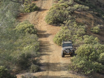
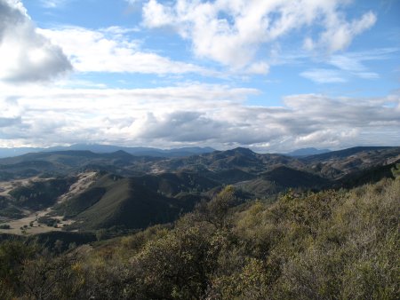
We’d had only one mildly challenging trail section up to this point, and that had turned out to be the only time I used low range all day. But we soon had another somewhat technical section, followed by a rutted and muddy trail leading to some wonderful views of the hills and a beautiful valley below. All of tougher paths were off of the main roads.
The biggest challenge of the day was then at hand, in the form of a lengthy attempt to reach a puzzle cache final. There was no good route to get to it, and faced with only bad options we chose one of the worst ones. It looked like a bushwhack through manzanita of less than a quarter mile to reach the cache, but it was .8 mile by the time we got there, all of us scratched-up and weary.
Dave now sported a half-dozen holes in his shirt, and I had at least eight scratches on my forearms, but only two were bleeding. Dan had powered through some branches and taken a spill among the volcanic rocks, but he got up quickly and appeared unscathed. One GPS was on its last legs of batteries, and we had no water or radios with us. Adding it all up, this was one of the dumber things I’d done in ages.
Fortunately, the risks were really pretty minimal, and we took a much shorter way back to the main trail (and our waiting rides) although even that route saw us on our hands and knees through brush on a very steep uphill climb. As someone once said, “Adventures suck when you’re having them.”
From there is was mostly back to the routine of drive-cache-drive, rinse and repeat, until we reached the northern entrance to the BLM lands. As with most of our visit here, this last leg was all on well-graded dirt roads. Along the way we got a wonderful sunset, and there must have been eight or more cameras clicking away at it between the oohs and aahs of appreciation.
Dave, my passenger, needed to be back to his car by around 1900hrs, so we and a few others aired up and bid the others adieu. Some of the others also headed out, while another group was going to backtrack some and then clean out the remaining caches before working their way home.
All in all, I think everyone really had a good time. If they didn’t, I haven’t heard about it! Even with the varied dispositions and personalities, it was a very fun group to share the trip with. I certainly enjoyed the day and am already looking forward to a return visit, with more offroading and less caching.
The photo gallery for this run is now available.