N35° 58.290′ W 121° 27.185′ – Part II
Or should I say, “the part with useful information”?
My friend Andy and I decided to do a full day trip down to explore the South Coast Road, which was in several of my guidebooks:
- Backcountry Adventures: Southern California (see Central mountains #49)
- California Coastal Byways (see Tours #21 and #23)
- Northern California Backroads and 4-Wheel Drive Trails (see Trail #52)
I’d been meaning to get there for several months now. One weekend the stars suddenly aligned, and off we went.
It turned out to be a long day (9:10am to 7:30pm), certainly much longer than we had planned and we still didn’t cover more than 40% of South Coast Road’s 26 miles. One issue was the estimated drive time from Garmin’s MapSource software, which was a bit optimistic. And of course, we made some stops along the way for pictures and such. And lunch, and gas, and rest breaks, and….
So I’d say a drive time of 2.5 hours is pretty aggressive for lumbering 4x4s like ours. With the photo stops but excluding lunch (an hour at the River Inn) it ended up taking us three hours of driving.
Once reason for all the stops was that I had the family in the Jeep with me, and Andy had his son Theo, and this made us more “high maintenance” 😉 than we would have otherwise have been. But that’s just a trade-off you expect with a fun family road trip. Also, not covering the entire trail just gives me a convenient excuse to go back again.
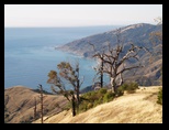
Everyone enjoyed the road, which was very easy this time of year (probably most cars could do it) and scenic. Where the foliage opened up allowing us to see further ahead, we were able to get on the gas more that we usually do while offroad. We encountered only two other vehicles on the road. The road was scenic and also a lot of fun… I could spend all day driving roads like that.
The fog we encountered briefly on the drive there (and also on the way home) didn’t hamper us on SCR, and the weather was perfect. It would be fun to camp up here somewhere when the evenings weren’t so cold. It’s such a nice area, and I’d wish it was just a bit closer to us, except that it would increase the crowds here and I can do without that.
- San Jose to the River Inn (N36° 16.226′ W 121° 48.515′ ) – 100 miles, 1hr 45min.
- River Inn to the start of SCR (approx. N36° 00.586′ W 121° 27.147′) – 37 miles, 1hr 15min.
- SCR start to the Mile 9.9 Waypoint (N35° 55.961′ W 121° 23.190′), including a stop out on the Prewitt Ridge sidetrail: 11.6 miles, 1hr 15min.
The Mile 9.9 Waypoint is from Backcountry Adventures: Southern California which was my primary source for planning this trip. Note however that their coordinates for the start of SCR are about 400′ ENE from my coordinates. Their’s will still get you close enough, but mine are better, and they also match both the MapSource city and topographic map data.